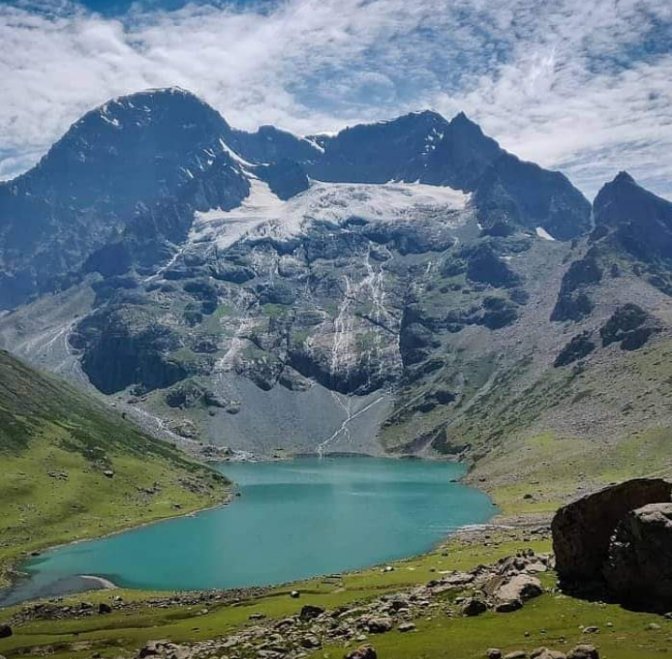
The Kashmir Great Lakes Trek , a journey that stands out for its unique features, is a trek that speaks for itself. Its name alone evokes images of breathtaking beauty and adventure. Nestled in the heart of the Himalayas, Kashmir is a haven for nature lovers and thrill-seekers alike. This trek offers a one-of-a-kind experience that will imprint unforgettable memories. The pristine lakes and snow-capped mountains are a sight to behold; their tranquillity and majesty will leave you in awe. The trek is an opportunity to immerse yourself in the natural beauty of Kashmir and create memories that will last a lifetime.
Kashmir, known as the earth’s paradise, is the location of this trek, which lasts around 7-9 days and is considered moderately challenging. The elevation reaches 13000 feet, and the distance covered is approximately 63 km. This trek provides an opportunity for self-discovery on multiple levels – physical, mental, and emotional. The experience of pushing one’s body to its limits and overcoming doubts about completing the trek is a challenge like no other. While the journey may be tough, the sense of accomplishment upon reaching the destination is unparalleled. This trek can be a happy and memorable experience for trekkers with proper preparation.
To embark on the challenging journey to the Kashmir Great Lakes Trek, it’s crucial to prioritize your health and well-being. Ensure you’re in top physical condition by engaging in regular gym sessions and incorporating activities like running, walking on an incline, cycling, cross-training, and stretching into your daily routine. Mental fitness is equally vital, so cultivate a positive mindset and practice stress-reducing techniques to help you cope with the demands of the trek. This preparation will not only make the trek more enjoyable but also increase your chances of successfully completing it.
Along the Srinagar road, the trek begins approximately 3 kilometres outside Sonamarg. You’ll encounter a few roadside restaurants and dhabas where you can grab snacks or light meals. It’s recommended that trekkers stop here to stock up on provisions, as the next opportunity for food and shelter won’t be until Naranag, which marks the end of the trail.
The path winds through a picturesque meadow with lush green grass, offering breathtaking views of the Sonamarg town below. As trekkers ascend, they reach the threshold of a dense forest, where towering Maple and Pine trees stand sentinel. The ensuing trail unfolds into a romantic paradise, with the dense canopy of Maple trees creating a dreamy, intimate atmosphere that is singular to this trek in India. This unique beauty of the trek is sure to intrigue and excite any adventure enthusiast.
The Kashmir Great Lakes Trek is a journey that speaks for itself. Its name alone conjures up images of breathtaking beauty and adventure. Located in the heart of the Himalayas, Kashmir is a paradise for nature lovers and thrill-seekers alike. This trek offers a once-in-a-lifetime experience that will leave you with unforgettable memories. The pristine lakes and snow-capped mountains are a sight; their tranquillity and majesty will leave you spellbound. The trek is a chance to immerse yourself in the natural beauty of Kashmir and create memories that will last a lifetime.
Kashmir, known as the earth’s paradise, is the location of this trek, which lasts around 7-9 days and is considered moderately challenging. The elevation reaches 13000 feet, and the distance covered is approximately 63 km. This trek provides an opportunity for self-discovery on multiple levels – physical, mental, and emotional. The experience of pushing one’s body to its limits and overcoming doubts about completing the trek is unmatched. While the journey may be challenging, the sense of accomplishment upon reaching the destination is unparalleled. This trek can be a happy and memorable experience for trekkers with proper preparation.
To embark on the challenging journey to the Kashmir Great Lakes Trek, it’s crucial to prioritize your health and well-being. Ensure you’re in top physical condition by engaging in regular gym sessions and incorporating activities like running, walking on an incline, cycling, cross-training, and stretching into your daily routine. Mental fitness is equally vital, so cultivate a positive mindset and practice stress-reducing techniques to help you cope with the demands of the trek.
Along the Srinagar road, the trek begins approximately 3 kilometres outside Sonamarg. You’ll encounter a few roadside restaurants and dhabas where you can grab snacks or light meals. It’s recommended that trekkers stop here to stock up on provisions, as the next opportunity for food and shelter won’t be until Naranag, which marks the end of the trail.
The path winds through a picturesque meadow with lush green grass, offering breathtaking views of the Sonamarg town below. As trekkers ascend, they reach the threshold of a dense forest, where towering Maple and Pine trees stand sentinel. The ensuing trail unfolds into a romantic paradise, with the dense canopy of Maple trees creating a dreamy, intimate atmosphere that is singular to this trek in India.
Altitude: 7800 feet It takes approximately 3 hours to drive 90kms from Shrinagar Xplorethedream can arrange pickup from TRC at 12 pm if booked in advance The campsite is located near the Sindh River (Shitkadi Village). There are no shops nearby so make sure you have everything you need. Keep your ID proof with you in the original and two photocopies. We will need them to check at the Army Check Post. In the afternoon, depart for Sonamarg. It takes 3 hours to reach Srinagar.
Altitude: 7,800 ft – 11,500 ft 11kms Trek, approximately 8 Hours We trek to Nichnai via Shekdur after breakfast. You will find the trail through dense forests of Maple, Pine, and Bhoj trees. We are allowed to go through the army checkpoint after about half an hour. Here we must submit our ID proofs. You can also enjoy a spectacular view of the Sonmarg Valley and the Thajiwas Glacier while you’re at it. It takes approximately 2 and a half hours to trek from Shitkadi, Shekdur through dense pine forests. You can enjoy instant noodles or an omelette at Shekdur if you so desire. As we trek from Shekdur, to Nichnai, we follow the Nichnai Stream. After Shekdur, we have lunch at Nichnai. The trek commences 3 kilometres from Sonamarg, along the Srinagar Road. After a brief 3-kilometer journey, you’ll encounter a solitary Dhaba offering snacks and refreshments. Naranag is the next settlement, located at the end of the trail. The jeep track diverges from the main road, veering right, and descends towards the Sindh River. The river flows parallel to the mud track and the main road. The trail follows a gentle curve to the left, traversing a picturesque meadow with breathtaking views of Sonamarg. Within half an hour, you’ll reach the meadow’s summit, where Maple and Pine trees begin to dominate the landscape. The trail then descends to a small brook, only to ascend again, leading you through a dense forest of Maple trees. The experience of walking on the lush green grass amidst these Maples is truly unique. The trail will lead you through a picturesque Maple tree forest for the next hour and a half. Stay on the uphill path; the downhill trail will take you to nearby villages. Enjoy the scenic views of the Sonamarg valley from the clearings between the trees. As you reach the top of the ridge, the Maple forest will give way to a meadow, offering stunning views of the valley below. Please take a moment to appreciate the scene’s beauty, with its streams, meadows, pines, and town nestled in the distance. After a brief climb, the trail will descend into a verdant meadow lined with Silver Birch trees and dotted with small brooks. This is Shekdur, a lovely campsite surrounded by Bhojs. If you’re starting your trek from Srinagar at dawn, Shekdur is an ideal first campsite. However, if you’re starting from Sonamarg, it’s too early to set up camp here. Instead, take a break at the meadow before continuing to Nichnai, the next campsite. The meadow lasts about half an hour before reaching a forest of Bhoj, or Silver Birch. Follow the trail through the forest and watch for the sun’s rays as they filter through the dense foliage, creating a dappled pattern of light and shadow. In approximately 45 minutes, you’ll reach the end of the birch tree line and begin your descent into the river valley, marking the beginning of Nichanai. The trail follows the right bank of the Nichanai River as it flows upstream, with the snow-capped peaks of Sonamarg Valley visible to your left. You’ll traverse a wide valley flanked by mountains, with the river Sindh flowing through it. The terrain will be rocky for the first 30 minutes, but eventually, the landscape will transform into a lush green meadow as the river valley narrows. Look ahead to spot the Triangular Twin Snow-capped Peaks in the distance.
Altitude: 11500 ft to 12,000ft through 13100 ft 12 km Trek, approximately 7 hours The trek from Nichnai Pass to Nichnai Pass takes approximately 1 and 1/2 hours. You can access the B.S.N.L network at the top of Nichnai Pass, which is the final point in the mobile coverage area. There is a descent from Nichnai pass towards Vishansar. Lunch will be served at the campsite Vishansar You can also visit the Vishansar lake, which is only 15 minutes from the campsite. This is the first and most beautiful lake on the trek. The lake will freeze if the trek takes place in July. If we have permission from Srinagar Fishing Department, we can fish at the lake. Vishansar is frequented by flocks of sheep, and their shepherds are well-known for telling interesting stories. This campsite offers a great place to play volleyball, cricket and other sports. Embark on a picturesque journey across meadows, with the scenery continually improving. Begin your trek by 8:00 am to allow ample time to appreciate the surroundings. Your first destination for the day is the Nichnai pass or Vishnusar Berry, visible from the campsite. The pass is a striking landmark located just right of the twin snow-capped peaks. Following a half-hour river-side walk, cross the waterway to transition to its left bank. Observe the trail gradually ascending as you advance through the meadow for the next hour. The subsequent hour is dedicated to a moderate climb to Nichnai Pass, standing at 13,500 ft, succeeded by a minor descent and an extensive flat meadow walk, ultimately leading to Vishnusar Lake. As you ascend, take notice of a small lake nestled at the base of the mountains, its deep blue hue igniting excitement for the lake. The pass is not immediately apparent from the meadow below, as the trail misleads with two inward turns before revealing the Nichnai pass. From this vantage point, take in the breathtaking views of the Sonamarg valley and the path you’ve traversed. This is a reliable spot to get a phone signal, courtesy of the BSNL network, which may not be available again until you reach beyond Gangabal. As you continue your journey, the path opens into a vast, snow-covered valley, with towering peaks rising up on your left. The landscape on the right side slopes upward, but no prominent peaks are in sight. You’re currently at an elevation of 13,229 feet, which is quite a feat, considering it’s only the second day of your trek. The high altitude can be challenging, but the good news is that the trail begins to descend from here, offering a welcome respite. The rugged terrain leads to a steep rocky path, eventually turning into lush green grass. Bright red flowers dot the landscape, adding colour to the otherwise muted tones. Ahead, a vast meadow stretches out for miles, flanked by towering mountains. A new river flows gently through the valley, providing a soothing soundtrack to your journey. As you pause, take in the breathtaking panorama of rugged peaks, glistening rivers, and vibrant meadows. To your left, a magnificent waterfall cascades down the mountain slope, merging with the river below. Beyond the waterfall, the terrain flattens out, and you continue your journey through the expansive meadow. The iconic snow-capped Himalayas rise majestically to your left, while the barren, grey mountains on your right evoke the stark beauty of the Ladakh ranges. Amble along the verdant valley, flanked by two towering ranges. Two prominent streams meander through the landscape, with the left-hand stream being your guide. Prepare for a refreshing stream crossing in a mere half hour, with crisp water leaving you invigorated. Set up camp in the meadow for 90 minutes until you reach the valley’s end. A stream flows from the left towards the right, originating from Vishnusar Lake, located higher up on the left but cannot be seen from the campsite. Pitch your tents in an open area near the stream, leaving plenty of space for other campers. The Vishnusar lake is 0.5 km to the left and 100 feet above the campsite. Head left and follow the stream to reach the lake, keeping it to your right. It takes approximately 7 minutes to reach the lake between two mounds. The first thing you’ll notice about the Vishnusar Lake is its size and how four mountains surround it. The Kishansar peak, located 0.5 km away, is reflected in the lake’s calm waters, creating a stunning visual effect. The lake’s colour varies depending on the time of day and the clouds in the sky. In the early morning, the water is crystal clear, but the lake takes on a blue hue as the sun rises. When the sun is high in the sky, and the clouds are few, the water appears a deep blue. However, in the late afternoon, the lake turns greenish-blue, thanks to the combination of clouds and the setting sun. Regardless of the time of day, the Vishnusar Lake is truly breathtaking and worth seeing in its different colours.
Note: Kindly note in our Kashmir Great Lakes Trek Day 04 is rest day (which is optional) and will be used as a buffer day only incase of any weather condition, shutdown, political unrest, using Rest day / buffer day will completely depends on current weather condition of the region or Kashmir Situation. In all good situations the trek will continue and rest day / buffer day will not be used, making it a 6N 7D program. If the rest day / buffer day is used Xplorethedream will not charge for its logistics.
Altitude: (12,000ft to (12,000ft), via (13.750ft). 14kms Trek, approximately 10 Hours The trek starts earlier than usual. The trek takes you from Vishansar up to Gadsar. The trail ascends steeply from Vishansar to Gadsar Pass. On the way, we can see Kishansar Lake. We descend slowly from the Gadsar pass to the campsite. En route, we can see Gadsar lake. The Glacier of Gadsar Lake might also be visible. We will arrive at the campsite after passing Gadsar lake. It takes us 2 hours. We will be stopped by another army checkpoint just a few minutes from our campsite. They will ask for our ID proofs. Lunch will be provided You’ll encounter a narrow trail that winds up the mountainside as you journey. This path will lead you to the summit, but be sure to follow the track that ascends higher, as it will provide the most scenic route. The climb should take around an hour and a half at a moderate pace, and about 45 minutes into your ascent, you’ll be rewarded with a breathtaking view of both Kishansar and Vishnusar lakes, nestled in the mountains. The scenic view of the twin lakes persists until you reach the ridge summit or the pass, known as the Gadsar pass, which stands at 13,800 feet, the highest point on this trek. The trek involves a strenuous 2-hour climb followed by a steep descent and a leisurely walk through the meadows. On the opposite side of the Gadsar pass, a long valley stretches out, with 2-3 small lakes visible in the distance. A series of snow-capped peaks can be seen on the far horizon, lying beyond our Line of Control. It is not unusual to encounter snow at the Gadsar pass and in the initial sections of the descent on the other side. The path downward is uncomplicated. The initial minor lake on the left is Yamsar Lake, which the local population believes has a connection to Lord Yama. Following Yamsar is a second unnamed lake. A short descent of an hour brings you back to level meadows. This valley is more compact, with two mountain ranges running along its sides. Take note of the vibrant flowers growing out of the green grass, beginning with red and gradually shifting to blue and purple irises. As you venture into the blue Iris area, you’re just a short distance from the breathtaking Gadsar lake, nestled at the foot of snow-capped peaks. Vibrant blue flowers bloom on one side, while snow slabs tumble into the lake from the mountain on the other. Ahead, the valley stretches out in a gentle green-blue slope. The Yamsar, the unnamed lake, and Gadsar are linked by a stream that flows from the higher lake to the lower, with Gadsar at an elevation of 12,500 feet. Select Gadsar as your campsite for its breathtaking beauty, but only if you promise to leave the area as pristine as you found it. Gadsar is typically unoccupied, and a small, abandoned military shelter is nearby. If you opt not to set up camp beside Gadsar, the next suitable location would be the army camp nearby. Following the downward trail from Gadsar, the valley expands after a half-hour walk, revealing a second blue lake on the left-hand side. The snow-capped mountains give way to rugged, barren peaks. You’ve descended a significant amount of altitude. Another half hour down the trail, a few shepherds’ huts come into view. Continue downhill for three and a half hours, and the army camp will be at the end of your journey. The Gadsar army camp comprises a small hut housing approximately 5-8 military personnel. To proceed beyond the military camp, authorization from the central command is required. The command centre is located 4.8 kilometres further down, near a village, and is situated among the trees. The Gadsar camp maintains contact with the headquarters using handheld radios. The headquarters is also equipped with a satellite phone for military use. If you are near the Gadsar army camp, it is advisable to report to them promptly. Processing your documentation, which includes verifying original identification cards, takes approximately 2-3 hours.
Altitude: 12,000 ft – 12,000ft 9kms Trek, approximately 6 hours. The trail is full of vibrant flowers from mid-July to mid-August. You will need to show your ID at another checkpoint of the army while you are on your way. We see two smaller lakes that are sometimes mistaken for Satsar Lakes. In the afternoon, we will visit the Satsar twin Lakes, which are approximately 1.3 h Mengen top is also known for Stasar twin lakes. These twin lakes can be found in the middle of the mountain. After crossing the stream, follow the trail that ascends the mountain, reminiscent of a typical western ghats path. You’ll feel above the tree line, with the tree-covered valley stretching below. The 1.5-hour climb will take you up 1,100 feet, and the trail will eventually transition into a traverse. You’ll leave the river valley behind and find yourself walking on a flat trail surrounded by mountains, with deep craters to your right. This area is known as Maengandob. The landscape ahead is breathtaking, with isolated mountains and a small ridge to your right. In between, you’ll find a flat green bed with a river flowing through it. Consider camping here if Gadsar Lake is your last stop. If you started at the army camp, it’s worth covering a bit more distance and setting up camp near the first of the Satsar lakes. Satsar consists of seven lakes, four or five containing water depending on the season. Located beyond the ridge on the right is the Satsar army check post, the third line of defence from the LOC. Expect to go through the usual identity checks, collection, and questioning process. It’s best to take care of this today to ensure a smooth and enjoyable trekking experience tomorrow. Just ten minutes from the army camp is the first of the Satsar lakes, a picturesque body of water nestled in a green setting with mountains rising in front. Choose a suitable spot to set up camp for the day.
Altitude: 12,000 ft – 11,500 ft 13000 11kms Trek, approximately 6 Hours For approximately an hour, we walk on rocky trails and then ascend to Jazz Pass. The pass offers views of Mt. Harmukh with its glacier. We descend to the Gangbal lake, and then camp at Nandkol lake. We will visit Gangbal Lake, one of the largest lakes on the trek. After dinner, a group of Kashmiri staff members will perform traditional songs and dances. The terrain undulates throughout the day’s trek, alternating between gentle inclines and declines, followed by a steep ascent and descent. The path replicates this pattern, consistently rising and falling. Begin by trekking for half an hour to reach the largest Satsar lake, traversing bouldery terrain requiring more hopping than walking. Beyond the final lake, the trail descends, and after a 30-minute walk, the forest line comes into view on the left, while a ridge line lies to the right, standing 1,000 feet taller. It’s time to gain altitude again, starting from 11,800 feet at the base of the climb. Use the zig-zag pony track to ascend the first ridge, a 45-minute journey with limited breaks. From the summit, two additional ridges remain to be climbed. The barren and rocky trail offers a contrasting view of the adjacent mountains, where Gujjar huts are visible amidst tall pines. The disparity between the arid mountains and the lush greenery on the other side is striking. After a two-hour ascent, you reach the summit of the third ridge, where you’re greeted with a breathtaking view. The altimeter shows an elevation of approximately 13,400 feet. The real treat, however, is the stunning panorama that unfolds before you. Two lakes sit side by side, with a stream flowing from the higher lake to the lower. Look closely and spot two more lakes in the distance, one on either side. The largest of the four lakes is Gangabal, and its companion is Nandkol. Your destination is now clearly visible, lying 1,400 feet below you. The path ahead involves a brief descent followed by a steep climb back to the lake. Take in the scenery and get ready for a challenging descent. Your final destination is either Gangabal or Nandkol. While the ascent is dry, you’ll cross a stream midway through the descent. Fill up your water bottles and press on. The steep descent takes about an hour and a half, after which you’ll find yourself in a lush green meadow. The meadow stretches from right to left, and a kilometre down the left, you’ll see the tree line again. Once you reach the base, the lake shore is still far off. Though the destination is now visible, it appears distant. A short climb, a quick descent, and a stream crossing over a wooden log bridge lead you to the shores of Nandkol Lake. Observe that this lake isn’t as pristine as the others you saw on the trek. The area is littered with remnants of camping. Many people trek up from Naranag to Gangabal and return as a weekend getaway, leaving behind a trail of garbage. You can’t help but wish they had taken the time to clean up after themselves and appreciate the beauty of these lakes. The picturesque Nandkol Lake is situated at the foot of the majestic Harmukh Peak, with the Harmukh Glacier gracefully descending the rocky slopes. Both Nandkol and Gangabal Lakes are renowned for their excellent trout fishing spots. While Gangabal Lake is a 20-minute trek away from Nandkol, a fiery stream flows between the two lakes, connecting them. To reach Gangabal from Nandkol, it’s essential to cross this stream using a sturdy artificial bridge on the right-hand side of the bank of Gangabal. The lake is vast, and a leisurely circumambulation of either lake will take around an hour.
Altitude: 11500 ft to 7450 ft 15kms Trek, approximately 7 hours You will be walking down the trail until you reach Naranag. Please take care of your ankles and knees. You will be passing through the pine forest. TrekupIndia can arrange transportation to Srinagar for a fee if you make an advance booking. You will arrive in Srinagar at 6:30 pm after driving 70kms. Prepaid sim cards are not valid in Kashmir. Carry Postpaid Sim Cards. You will reach Srinagar on Day 8 between 6:30 and 7:30 PM. After 8 PM, you can book your travel. After a gentle downhill journey for 6 hours, the trail becomes much steeper and more challenging for the final 11 kilometres. Today’s journey may seem effortless as you descend downhill, but be mindful of the steep incline that may strain your knees. Begin your trek from the Gangabal campsite, following the stream and ridgeline until you reach a grove of trees. After 30 minutes, you’ll start getting cell phone reception, so take a moment to let your loved ones know you’ve made it safely. As you continue, the ridge will give way to a picturesque meadow, offering a stunning view of Harmukh Peak in the distance. As you continue your journey, you’ll notice the landscape shift, with the treeline coming into view. Most of the trees are pine, and you’ll begin to see signs of civilization, such as a log hut, as you make your way deeper into the forest. The trail takes you in and out of the woods for about 6 km without much change in altitude. However, as you reach the two-thirds mark, the path begins to descend, which is quite steep. The trail is muddy and well-trodden, and the thick pine cover creates a canopy overhead. Over the final 4 km, you’ll experience a dramatic drop in altitude, losing over 3000 ft. You may see other trekkers on their way up from Naranang to Gangabal. As you continue down, Naranang comes into view, and the end of your trek is in sight. The last portion can be challenging, as the path is quite steep, but a stone-paved path appears, and you’ll soon enter the village of Naranang. From there, you’ll drive to Srinagar, with an estimated arrival time of 6:30 pm. From this point, you can make further travel arrangements as needed.
Reserve your ideal trip early for a hassle-free trip; secure comfort and convenience!
Leave a comment: